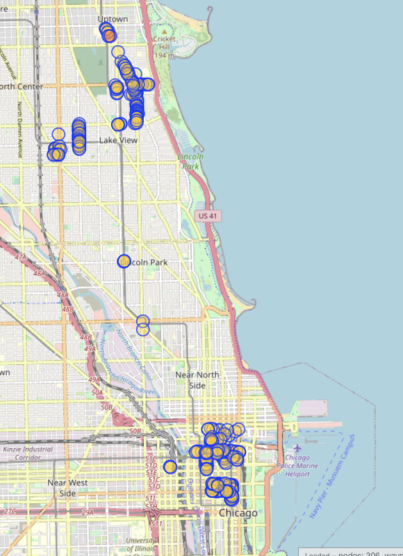
I’m continuing on my quest to map all the bike racks in Chicago, but it’s going a bit slower than I thought. Last update, I had a little less than 200 racks mapped, which is pretty good progress. This update I’ve gotten to 306. Here’s a look:
I got a suggestion last time to try using data from the city to help map the racks. Unfortunately, the data from the city isn’t super accurate. It can be off by as much as 2 blocks using the map on the official website. So I got data that was a little more updated, stripped the locations from it (the geocoder used was inaccurate) and punched it into Google MyMaps to see how accurate it was. It’s better, but still not something I’d want to use for actual mapping.
Another approach I’ve tried is using Mapillary. I bought a 360 camera and recorded a few tracks around town. Supposedly they’ll automatically tag stuff using computer vision (bike racks included), but none of my sequences posted more than a week ago have been tagged yet.
Additionally, the camera I bought (GoPro Max) takes great photos, but it doesn’t have world lock or horizon leveling enabled for the timelapse feature that I use for Mapillary. So some of my photos look pretty off-kilter. But they’re still super helpful for mapping from home so I’m not having to physically go to all the locations I want to map!
My current approach is to map racks while I’m out at work (as you can see in the loop) or to map them using Mapillary data as I’ve ridden by (the ones in Lakeview and at Southport). This seems to work okay, but given the sheer amount of bike racks in Chicago I don’t know if it’s super scalable. I’m going to hope Mapillary figures out stuff on their end and auto-tags my tracks as that would make the process significantly faster.
Discussion
Comment from lectrician1 on 16 October 2022 at 16:33
Awesome! Keep it up! There are SO MANY roadside single bike stands downtown it’s kind of crazy. Good luck!
Comment from Pieter Vander Vennet on 17 October 2022 at 16:45
https://mapcomplete.osm.be/cyclofix allows to add bicycle racks on the field (if you zoom in enough)
Comment from Xvtn on 17 October 2022 at 22:41
Nice work! I’ve also been (much more casually) mapping any bike racks I’ve seen on my school’s campus. Still very frequently, I notice new ones even after doing so for almost a year. They are easy to miss or gloss over!
Comment from yopaseopor on 18 October 2022 at 15:57
Have you tried Deriviste? You can configurate what want to put in with Mapillary images.
Comment from epicspongee on 19 October 2022 at 04:12
Wow folks thanks for all the comments!
I mainly use iD as my editor at home and Go Map!! when I’m out and about. The vast majority of these I end up adding using ground surveys while I’m waiting on Mapillary imagery to process. I’ve uploaded about 20GB of 360 photos to Mapillary, but it can take them up to a month to process with photo tagging. Hopefully the process goes muchhhhh faster after that’s done.
Haven’t tried out other editors, but I think what I have works for now. iD will import the objects from Mapillary when they finish their processing :)